

Field Navigator

Description of Field Navigator
Field Navigator is a precision agriculture application designed to assist farmers in navigating their fields using parallel driving techniques. This app is available for the Android platform, allowing users to download it for easy access. Field Navigator is particularly beneficial for both large and small farm owners, as it helps in efficiently managing field operations while minimizing costs.
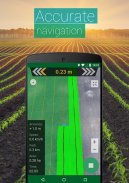
The primary function of Field Navigator is to enable users to drive in parallel lines while working in their fields. This feature significantly reduces workload and improves accuracy by minimizing untreated areas and preventing overlaps during tasks such as planting and spraying. Users can easily create and manage their field layouts, facilitating a more organized approach to farming practices.
One of the key aspects of the app is its ability to measure field size accurately, even under challenging conditions, such as poor visibility. This functionality allows farmers to assess their land without the need for expensive additional equipment. By leveraging built-in GPS capabilities, users can gather essential data about their fields and optimize their operations accordingly.
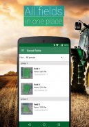
Field data, including borders and guidance lines, can be saved within the app. Users can also mark obstacles on their fields, creating a comprehensive database tailored to their requirements. The app's ability to record and manage this information is critical for effective planning and execution of farming activities.
Field Navigator supports the creation of Straight AB parallel lines, which simplifies navigation in the field. This feature is particularly useful for tasks requiring precise alignment, such as planting rows or applying fertilizers. The app guides users through a series of steps that enhance the parallel driving experience, ensuring users can operate efficiently.
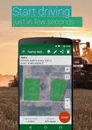
In addition to driving assistance, Field Navigator allows users to create a digital fields database either by using GPS or by manually selecting points on a map. This flexibility caters to various farming styles and preferences, making it adaptable to different users’ needs. The app also provides users with the ability to measure field area and perimeter, contributing to more informed decision-making regarding land management.
Importing and exporting field data in various formats, such as *.shp and *.kml, is another feature offered by Field Navigator. This capability ensures seamless integration with other tools and software, allowing users to share essential data with colleagues or stakeholders in their agricultural endeavors.
Field Navigator is designed to enhance the overall farming experience through its user-friendly interface, which makes navigation straightforward. Users can easily create tracks on Google Maps in satellite view, providing a visual reference that aids in planning and execution. This visual aspect of the app enhances users’ understanding of their fields and supports more effective management.
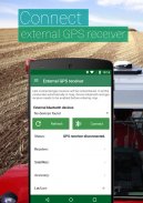
For users seeking to improve their GPS accuracy, the app is compatible with external Bluetooth GPS receivers, such as the GARMIN GLO. This feature ensures that users can achieve an accuracy of up to 0.3 meters, which can be crucial for precision agriculture tasks. The integration with GARMIN devices has been tested and proven effective, offering an additional layer of reliability for users.
Future updates for Field Navigator are expected to include features like AB Curve navigation, headland management, and the ability to mark obstacle positions. Users can also look forward to a farming activities database and driving assistance in a 3D mode without maps. Additionally, the introduction of a night mode will enable farmers to operate even during low-light conditions, further enhancing the app’s utility.
To initiate parallel driving, users must create a field within the app. This process is straightforward and involves selecting the irregular hexagon icon located in the top right corner of the interface. Once the field is established, users can follow the clearly displayed steps on the navigation panel to begin their farming activities.
Field Navigator serves as a valuable tool in the realm of precision agriculture, aiding in various tasks such as seeding, spraying, and harvesting. Its features cater to a wide range of agricultural practices, making it useful for farm contractors and those utilizing various farming equipment brands, including John Deere, New Holland, and Case.
The app's focus on accuracy and ease of use positions it as an essential instrument for modern farmers. By utilizing the capabilities of Field Navigator, users can optimize their farming operations, ultimately leading to improved productivity and efficiency in the field.
For more information on the app and its features, users can explore further resources and updates.


